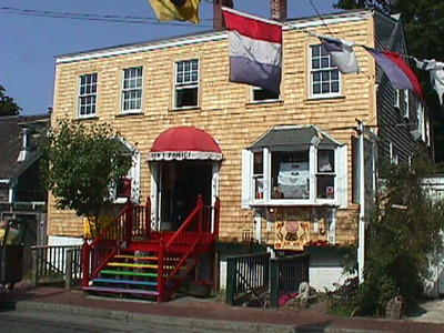
192-194 Commercial St
Historic District Survey information for 192-194 Commercial St | |
Architectural Description: 192-194 Commercial St. is a 2-story, 3-bay, vernacular Colonial Revival-style, center-entry cottage that has been converted to commercial use; side-gable roof is sheathed in asphalt shingles; exterior is clad in wood shingles with wood corner boards and trim; building sits on a brick foundation; fenestration includes 6/6 vinyl replacement DHS on 2nd story with wood sills, 1st-story bay windows have 1/1 DHS replacements, west facade has 6/6 replacement DHS and 8/8 DHS, east facade has 9/6 DHS wood windows; primary entrance is accessed by paired doors sheltered by a round cloth awning with a wood stoop with wood balustrade; modern below-grade basement entries flank front stoop; building was once 1-1/2-stories in height before 2nd-story added at later date; 3-story addition with 6/6 DHS and separate entry extends from the rear facade. |
|
Historical Narrative: As per Josephine Del Deo (1977): "The house would appear to be very old from the style of architecture and the window sizes. The 1858 map shows the building in the name of Freeman. How long before that the Freeman's ownership goes back is not known. Since Freeman is a common name in the time when Long Point settlement was moving back to the mainland, it's possible the building could have been there in 1820 or 1830. Again, it is in the center of busy shop area and an active portion of town."
As per Tom Boland (1994): "The site was formerly 191 Commercial Street. Not shown in 1858, this house was owned by G. Holmes in 1880, and by 1889 it was the site of a millinery owned by Miss E.B. Freeman. In 1901, the owner is listed as Bessie D. Freeman. Although altered, the structure retains a sense of its original character and still contributes to the character of the street."
SIGNIFICANTLY ALTERED - NEEDS CHANGE NARRATIVE |
|
Bibliography and/or References: Barnstable County Atlas., 1880.
Barnstable County Atlas., 1907.
Cape Cod Directory, 1901.
The Extremity of Cape Cod. Map, 1836.
H.F. Wallings Co. Map of Provincetown Village. Atlas, 1858.
Jennings, Herman A. Provincetown. or Odds and Ends from the Tip End. 1890.
Resident Directory. W.F. Richardson & Co., 1886.
Resident Directory. W.H. Hopkins, 1889.
Ruckstuhl, Irma. Old Provincetown in Early Photographs. Toronto, 1987. |
|
Text |
|
Commercial Street (Provincetown, Mass.), Dwellings, and Historic Districts--Massachusetts--Provincetown |
|
Comments (0)
NOTICE: It appears you do not have Javascript enabled in your Web browser. To access some of the features on the site (including email links) you must enable Javascript and refresh the page.


There are no comments for this archive.