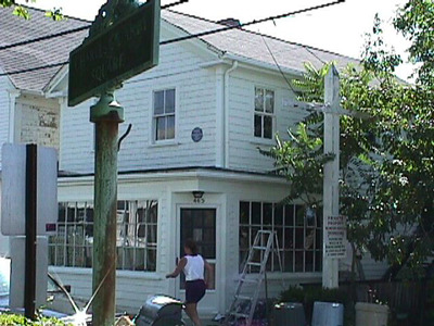
465 Commercial St
Historic District Survey information for 465 Commercial St | |
Architectural Description: This property appears to be connected to 467 Commercial Street; 465 Commercial St. is a 2-story, vernacular Greek Revival-style mixed-use commercial/residential building; gable-front roof is sheathed in asphalt roof shingles, partial cornice return; exterior is clad in wood shingles with wood corner boards and trim; building sits on an obscured foundation; fenestration includes 2/2 wood DHS; enclosed porch with 33-pane storefront windows; canted corner entry is accessed by a wood pane-and-panel door; rear 2nd-story porch. |
|
Historical Narrative: As per Tom Boland (1995): " Numbers 463 and 465 Commercial are listed in the 1858 atlas as being the E. & E.F. Cook Store and S. Bangs Sail loft respectively. It is also shown that, at that time, a wharf was attached to the property although it may have existed earlier. In 1880, the entire property was owned by S. Bangs but the grocery store here was known as the S.G. Cook Store. By 1907, the property was under the ownership of Messrs. David C. Stull, M. Silva and W.C. Snow who called it the Consolidated Weir Company (later know as the Atlantic Coast Fisheries). Mr. Stull, as noted in the 1901 Directory, specialized in fine lubricating oils made with whale oil as he was a well known trader in ambergris; while Mr. Snow was known as a shipsmith. #463 later became what is reputed as the first nightclub in town in the 1920s known as the Flagship (still the Flagship restaurant). 463A, the rear portion of the building bridging 463 and 465, was moved to its current location from the original wharf in 1927. The Beachcomber's Club, an artists' supper club was based here. Of all the structures in the area, this contains the most original integrity. William Boogar, Jr., the sculptor, used the former blacksmith shop at #463 (gone) as his studio in the early part of this century. The Grocery store at #465 was known as Burch's Store in the 1920's."
Plaque on wall: Whale Oil Refinery of David C. Stull, 1844-1926, 'The Ambergris King';
Plaque on wall: "Montezuma" (2003).
v306: |
|
Bibliography and/or References: Barnstable County Atlas. Atlas, 1880.
Barnstable County Atlas. Atlas, 1907.
Cape Cod Directory, 1901.
The Extremity of Cape Cod. Map, 1836.
H.F. Wallings Co. Map of Provincetown Village. Atlas, 1858.
Provincetown Advocate. November 11, 1984.
Resident Directory. W.F. Richardson & Co., 1886.
Resident Directory. W.H. Hopkins, 1889.
Vorse, Mary Heaton. Time and the Town. |
|
Text |
|
Commercial Street (Provincetown, Mass.), Dwellings, and Historic Districts--Massachusetts--Provincetown |
|
Comments (0)
NOTICE: It appears you do not have Javascript enabled in your Web browser. To access some of the features on the site (including email links) you must enable Javascript and refresh the page.


There are no comments for this archive.